


Hamars/sous le mont d'Ancre

geoffrayLayeux
User
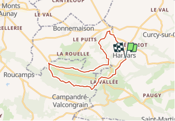

Length
13.2 km

Max alt
249 m

Uphill gradient
304 m
Km-Effort
17.3 km

Min alt
98 m

Downhill gradient
302 m
Boucle
Yes
Creation date :
2021-12-12 15:29:33.783
Updated on :
2021-12-12 15:30:24.675
3h55
Difficulty : Difficult

FREE GPS app for hiking
 SityTrail
IGN / Geographical institutes
SityTrail Plus
The world is yours!
About
Trail Walking of 13.2 km to be discovered at Normandy, Calvados, Le Hom. This trail is proposed by geoffrayLayeux.
Positioning
Country:
France
Region :
Normandy
Department/Province :
Calvados
Municipality :
Le Hom
Location:
Hamars
Start:(Dec)
Start:(UTM)
679503 ; 5430102 (30U) N.
Comments